
Spray the patch,not the paddock.
Spot and broadacre aerial application by accredited operators. Get into wet ground, steep country and tight corners a boom cannot reach, without a wheel track through the crop.
Licensed & insured pilots
No lock-in, ever
Illustration of swath and overlap. Not a flown job.
The paddock you cannot get a machine onto is usually the one that needs it most.
Wet ground, steep country, timbered edges and awkward corners are exactly where weeds and disease get established, and exactly where a self-propelled boom either cannot go or does damage getting there.
An aircraft has no wheel tracks, no compaction and no bogging. Paired with a multispectral map, it can also apply to just the zones that need it.
Spot application following a prescription map across a paddock
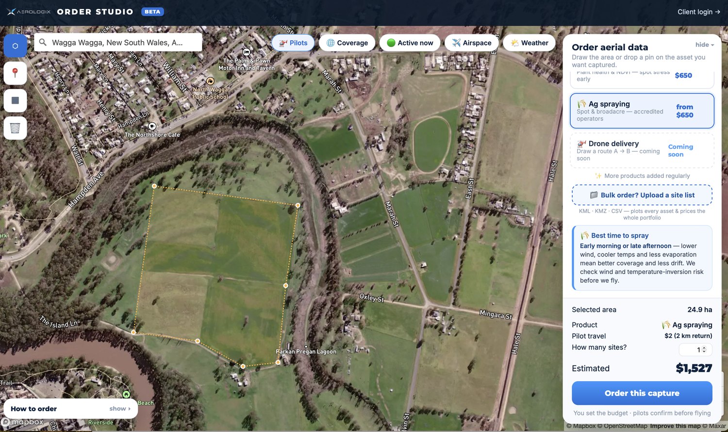
Real order: 24.9 hectares of ag spraying at Wagga Wagga, priced live at $1,527 as the boundary was drawn.
Treating the zones that need it, and leaving the rest of the paddock alone.
What you actually get.
Formats, accuracy and turnaround, written down before you order rather than discovered afterwards.
Figures above are published specifications for the aircraft and sensor class used for this work, or typical industry ranges. They are indicative. The exact payload assigned to your job depends on the site, and we will confirm the tolerance your project needs before we fly.
Price it yourself, right now.
Draw your site or tap the property on a map and the price appears while you are still moving the cursor. No quote request, no scoping call.
Where this earns its money.
Wet and boggy ground
Apply when the ground will not carry a machine, without leaving ruts.
Steep and timbered country
Slopes and edges a boom cannot safely work.
Spot spraying from a map
Fly a multispectral map first, then treat only the zones that need it.
What lands in your portal.
- As-applied map what went where, at what rate
- Application record timing, product, rate and conditions, for your records
- Flight log the actual flown path, not the planned one
- Follow-up mapping on request, to verify the response
Everything comes back into your enterprise portal. Already paying for ESRI, Bentley, DroneDeploy or Pix4D? Tell us at the point of ordering and it goes straight there instead. Raw data is retained on Aerologix servers either way, so you can come back for it.
Three clicks, honestly.
Pick this product
Choose it in Order Studio. The price is worked out from your selection, so nothing happens on the map until one is picked.
Mark your site
Draw the area, drop a pin, or tap the property and we pull the registered lot boundary straight from the state cadastre.
See your price and order
The estimate updates live. A licensed, insured pilot local to your site gets dispatched from the network.
See the number before you commit.
| Job | What it covers | From |
|---|---|---|
| Base | Mobilisation and setup | $650 |
| Per hectare | Applied area | +$35/ha |
| Spot from a map | Priced on the treated area, not the paddock | Ask |
Pricing shown is the starting point. Order Studio calculates the real number from your actual site, including pilot travel, before you commit to anything. Quoting is free and unlimited.
Stop waiting three days for a quote.
Seven years of flying across Australia, turned into a price that updates as you drag the cursor around your site.
Where this is the wrong product.
Every supplier will tell you what their product does. Fewer will tell you what it does not, which is usually the more useful half.
We fly it, you own the chemical decision
Product selection, rate and withholding periods are the grower’s or agronomist’s responsibility. We are not agronomists and will not pretend to be.
Label and permit conditions still apply
Aerial application has its own conditions. If the label does not permit it, we will not fly it.
Wind is the hard limit
Drift risk governs the window. Expect the flight to move rather than be flown badly.
Not a replacement for a boom on broadacre
On big, flat, dry, accessible country a ground rig is usually cheaper per hectare. This earns its money where the rig cannot go.
The things people actually ask.
Who supplies the chemical?
You do, along with the rate and the product decision, normally through your agronomist. We fly the application and give you the as-applied record.
What work rate can you achieve?
Around 21 hectares per hour in broadacre conditions and around 4 hectares per hour in orchard work, using a T50 class aircraft.
Can you spray only the affected zones?
Yes, and that is usually the best value in this product. Fly a multispectral map first, then apply to the stressed zones only.
What stops you flying?
Wind, principally, because of drift. Also label conditions, permit conditions and proximity to sensitive areas. We will move the flight rather than fly it badly.
Any drone. Anywhere.
Licensed, insured pilots across Australia. Price it yourself in a couple of clicks, or talk to a human on 1800 570 518.


